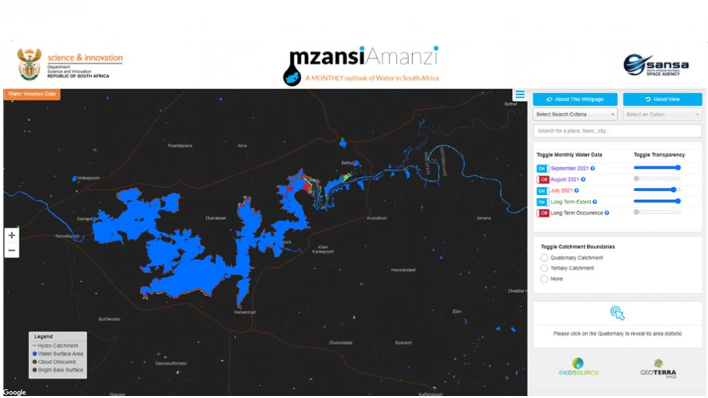
The National Water Quantity Monitoring System, or Mzansi Amanzi, is providing comprehensive data on South Africa’s water levels in dams, natural lakes and estuaries. This is being used by government and other relevant decision-makers for monitoring and to make informed decisions that improve water management and reduce impacts associated with drought and flood hazards.
The National Water Quantity Monitoring System extends the monitoring capability to almost the entire South Africa’s usable water footprint. This provides a better idea of the overall water security related to water supply on a continuous basis.
The National Water Quantity Monitoring System is a joint development between integrated geospatial solutions company Geoterra Imaging and water resource solutions company EkoSource Insight. The internal initiative was fully funded by the partnership and taken to its operational stage.
The South African National Space Agency (Sansa) then joined the project as a government-based collaborative partner to distribute the system to government departments.
The partnership allows all government departments to access this information. The licence extends to all partner and supporting consultants of these departments who have access to the information which can then be used to improve both operational and planning decisions.
The addition of Sansa in the partnership enabled Geoterra Imaging and EkoSource Insight to extend the service offering and improve its accuracy and reliability.
The system is updated on a monthly basis allowing for better water management decisions such as whether to impose water restrictions in municipalities, deploy disaster relief, issue flood or drought warnings, or release water for dam safety purposes, to name a few. These pre-emptive actions can reduce or prevent the impacts related to drought and flood hazards.
The Valus of the Technology
Geoterra Imaging director Mark Thompson explains that the aim of the system is to provide direct, comparable, standard and regular information as decision support for activities such as resource management.
“This is an enhancement of the data quantity and data quality that can be fed into existing tools, and of the procedures that are used to manage our water resources, both from a national risk scenario and for individual catchment managers and farmer groups,” he explains.
The system, which is built around Earth Observation technologies, has an all-weather capability allowing it to report the same quality of information regardless of weather conditions every month. It is a scalable, weather independent, fully functional, automated process that runs using cloud-based technologies. Developments and additions are continually added to improve the system and the value it provides.
Thompson explains that, apart from quantifying where water resources are, the system is also able to provide an indication of the volume of water available at the locations. The information can then be converted into usable water quantity to understand how long the available volume of water will last.
EkoSource Insights director Jason Hallowes explains that one of the most important aspects of water resource monitoring is water security.
He explains that only about 240 large dams are monitored across South Africa. However, a large number of municipal, industrial and mining water supply dams, mine tailings dams, and farm dams are not accounted for. The system monitors about 280 000 of these smaller dams. While a major portion of South Africa’s water is stored in the larger dams these smaller dams cumulatively have an impact on water resources by storing and intercepting portions of the runoff which would otherwise make it to the large dams, thus impacting the overall water supply.
Further, the system is able to monitor supply dams to smaller communities and municipalities. Therefore, there is now information available which enables decision-makers to evaluate if these communities are at water risk. Dams that also represent a safety risk such as mine tailings and structurally unstable dams can also be monitored to ensure they do not get too full and fail.
The Earth Observation technologies on which the systems are based have been designed to be independent of any on-site measurements, typically associated with costly equipment set-up, maintenance and risk. The system is a highly efficient, low-cost service that supplies more information than is currently available.
“Earth Observation technologies act independently of administrative boundaries. A lot of the water resources that we have within the country are actually shared in terms of the base and extent with cross-border countries,” explains Thompson.
The system can provide details of water bodies across the entire drainage basin, which relevant organisations can use to share water resources in a given catchment if it is split by an international boundary. Therefore, countries that share the drainage basin can have open and equitable access to the same information to make fair decisions.
The Valus of Partnering
Sansa remote sensing technologist Lesiba Tsoeleng explains that Sansa provides various services using space-based technology, such as the dissemination of Earth Observation data products and value-added services that promote socioeconomic benefits.
“We also provide a conducive environment where we partner with industries. As a distributor of the system, it is beneficial to use tools available from private industry at public enterprises to enhance our service offering,” he adds.
There are also public access platforms of the system which allow the public to monitor the progress of water resources. The website provides information for a period of three months at a time and is updated on a monthly basis, Tsoeleng concludes.
Edited by: Zandile Mavuso
Creamer Media Senior Deputy Editor: Features
EMAIL THIS ARTICLE SAVE THIS ARTICLE
ARTICLE ENQUIRY
To subscribe email subscriptions@creamermedia.co.za or click here
To advertise email advertising@creamermedia.co.za or click here


